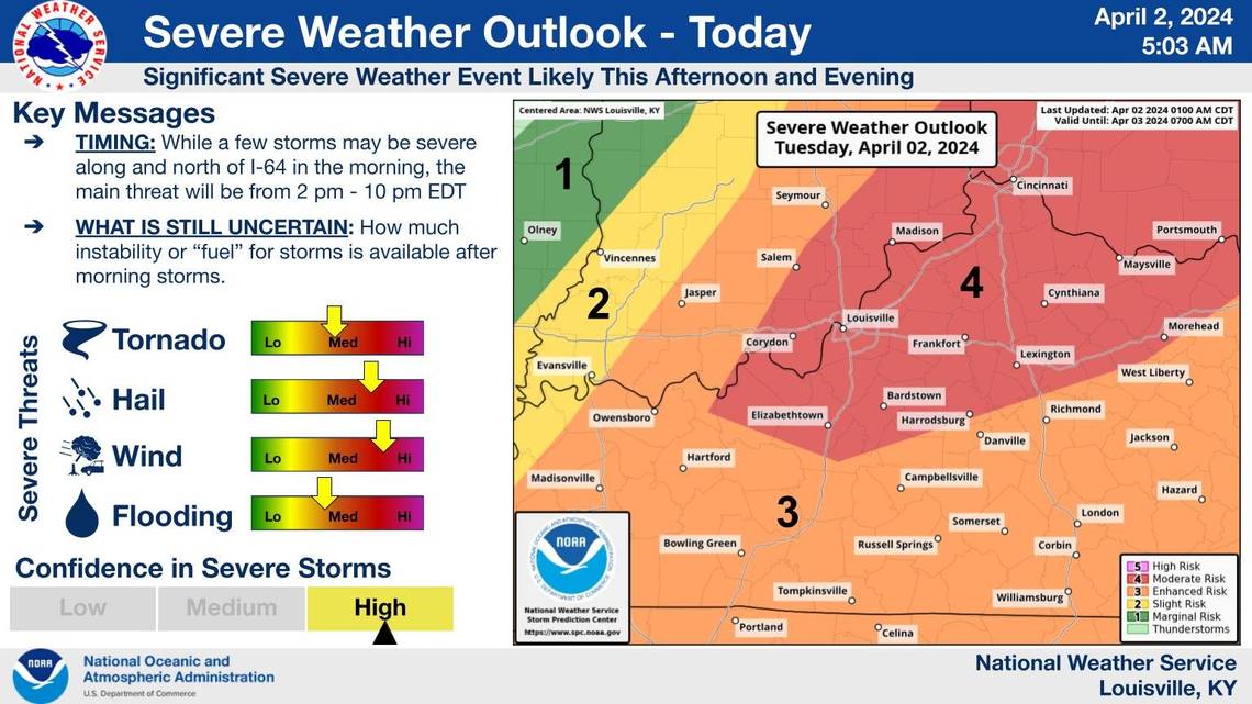
The severe storms are expected to be at their strongest between 2-10 p.m. along and north of I-64, the NWS said. How much instability or “fuel” the storms have is still unknown, but all major hazards are in play.
Projections of the storm indicated scattered supercell thunderstorms are likely, according to the NWS’ forecast discussion. A supercell storm is potentially the most dangerous of the convective storm types, capable of carrying violent tornadoes, downburst damage and large hail.
The NWS has already issued a tornado watch for parts of Central Kentucky, including Lexington, for the entire day Tuesday.
Baseball sized hail, 80 mile per hour winds and possibly strong tornadoes are all possible, according to the NWS. There is a 30-44% chance of experiencing hail and wind damage and a 15-29% chance of seeing tornado damage in the Central and Northern Kentucky area.
️️Severe storms will move through the region today. Damaging winds, large hail, and tornadoes are possible.
Stay weather aware and have more than one way to receive a warning. #kywx #inwx pic.twitter.com/QVYfRzftQt— NWS Louisville (@NWSLouisville) April 2, 2024
Most of Kentucky falls in the enhanced risk zone of the NWS’ severe weather outlook. Parts of Central and Northern Kentucky are under moderate risk, indicating a higher chance of experiencing severe weather.
Flooding is also possible, as rainfall amounts are expected to be around 1.5-2 inches, according to the NWS. A flood watch is in effect for Bourbon, Clark, Fayette, Franklin, Harrison, Henry, Nicholas, Scott, Trimble and Woodford counties until at least this evening.
At 7 a.m. there was a dangerous line of severe storms spotted in Western Kentucky moving eastward. The NWS said the storm should be near or along I-65 around 8-8:30 a.m. and 70 mile per hour wind gusts and tornadoes are possible from the storm.
Parts of Western Kentucky and southern Indiana are under a tornado warning and severe thunderstorm warning, according to the NWS. The storm is not expected to threatened central Kentucky.
7am EDT Radar update: #KYwx #INwx a dangerous line of severe storms is headed eastward. Should be near/along I-65 the next 60-90 min. Damaging wind gusts of 70 mph and tornadoes are all threats with this line of storms. Be weather aware this morning. pic.twitter.com/ratl7dqbWm
— NWS Louisville (@NWSLouisville) April 2, 2024
