
“The severe threat through the evening is greatest near and north of I-20,” Fort Worth meteorologist Allison Prater wrote on the NWS website. “Overall, the tornado threat looks to be on the lower side as winds generally stay veered to the south/southwest.”
Although the potential exists for increased tornado threats in counties to the west of Dallas-Fort Worth as winds intensify, Prater wrote.

⚡ More trending stories:
→ There’s no ‘better place’ to see April 8 total solar eclipse than in this tiny Texas town.
→In Texas, set your thermostat at 80 when it’s 100 degrees, expert says.
→Groceries at this national chain are the cheapest, study finds.
The thunderstorms could creep into the area sooner depending on how quickly the cap over the Plains erode Monday afternoon, giving way for the dry line — the boundary between moist air drawn up from the Gulf of Mexico and the drier air blowing across the deserts of the southwestern United States and northern Mexico — to commence its march eastward towards the I-35 corridor.
“The main uncertainty lies in how much heating we are able to observe during that time,” Prater wrote. “There remains a small chance that the cap could erode earlier, and if it did, storms may kick off along our Big Country counties off the dry line.”
Although the forecast calls for a lower threat of tornado, North Texas is entering its season of severe storms. April through May is when the region sees the most tornadoes touching down. It is also the time for spring beauty as Texas’ state flower, the bluebonnets, blooms along roadsides and pastures.
The weather service reminds residents to stay informed about tornado watches and warnings through regular updates on local news or a NOAA Weather Radio.
As this line of storms move through the region, a cold front coming behind it will bring cooler temperatures across North Texas by Tuesday morning, with morning lows in the mid 40s to low 60s.
“A cold front early Tuesday will bring an end to the early week rain event and begin an extended rain-free period,” the NWS forecast states.
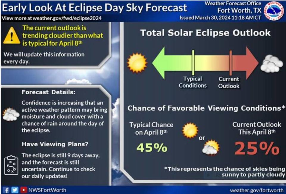
Weather outlook for Dallas-Fort Worth for April 8 total solar eclipse
The good news: That the region is drying out.
And the bad news? “Spring storm chances will return during the latter half of the weekend, unfortunately just in time for the long-awaited solar eclipse,” says the weather service.
Eight days out and it looks like there is a 25% chance the skies over North Texas during the total solar eclipse on April 8 will be covered in clouds.